해남 전라우수영
| 해남 전라우수영 Navy Headquarters of West Jeolla-do Province, Haenam |
|
| 대표명칭 | 해남 전라우수영 |
|---|---|
| 영문명칭 | Navy Headquarters of West Jeolla-do Province, Haenam |
| 한자 | 海南 全羅右水營 |
| 주소 | 전라남도 해남군 남문길 25-2 (문내면) |
| 지정(등록) 종목 | 사적 제535호 |
| 지정(등록)일 | 2016년 9월 30일 |
| 분류 | 유적건조물/정치국방/성/성곽 |
| 시대 | 조선시대 |
| 수량/면적 | 362필지 166,622㎡ |
| 웹사이트 | 해남 전라우수영, 국가문화유산포털, 문화재청. |
|
|
|
해설문
국문
우수영은 조선 시대에 전라도와 경상도의 우도(右道)에 두었던 수군 절도사의 군영이다. 전라 우수영은 서울에서 볼 때에 전라도의 오른쪽인 해남에 두었다. 그래서 해남 우수영이라고도 한다. 해남 우수영은 남해와 서해가 만나는 모서리에 위치하고 연안 해로에서 반드시 통과해야 하는 군사적 요충지여서 조선 시대 수군 사령부를 설치하였다.
전라 우수영은 전라북도 옥구에 있었으나, 무안 대굴포, 목포의 당포를 거쳐 세종 22년(1440)에 해남 우수영으로 옮겨 왔다. 성종 10년(1479) 여수 내례포에 전라 좌수영이 생기자 전라 우수영으로 개편하여 운영하다가 고종 32년(1895)에 없앴다.
연영(蓮營)이라고도 불렀던 해남 우수영에는 455년 동안 340여 명의 처치사와 우수사가 파견되었다. 초대 처치사는 무안 출신 윤득홍(尹得弘)이고 마지막 우수사는 권봉규(權鳳圭)이다. 이들의 임무는 해안 방어 외에도 조세의 운송, 봉화의 관리, 섬의 치안 등 다양했다.
전라 수영의 관할 해역은 전라북도 군산에서 전라남도 광양까지였다. 그러나 좌수영이 생기면서, 우수영의 관할 해역은 전라 우도인 군산에서 장흥까지로 축소하였다. 따라서 우수사는 연안 고을인 7개 고을(나주․영암․진도․무안․함평․진도․해남)과 수군진 20여 곳(군산진~회령진)만 통솔하게 되었다. 그러나 전라 우수영은 관할 구역은 물론 병선, 수군 등의 규모가 좌수영의 약 3배에 이르렀다.
조선 시대 전라 우수영 관련 유적으로는 우수영성과 원문성·객사(교회와 옛 우수영 초교)·동헌(옛 면사무소)·태평정·명량대첩비·망해정·군기고와 영창고·방죽샘·선소·남장대·북장대 등이 있다. 우수영성은 전국에 있는 수영 중에서 가장 규모가 크며 외성(外城)*으로 원문성을 축조하였는데 이는 드문 경우여서 가치 있는 문화재이다. 또 태평정은 명량대첩 이전에 이순신 장군이 우후 이정충과 밤늦도록 왜구 대책을 논의한 의미 깊은 망루 겸 정자이다.
해남 우수영은 조선 시대 수군 사령부가 있던 곳이고, 세계적인 해전으로 평가 받는 명량대첩의 배후 기지 역할을 했던 곳이며, 전국 수영 중 유일하게 옛 모습을 간직하고 있어서 역사적․학술적․문화적으로 가치가 높다.
- 외성(外城): 성 밖에서 겹으로 둘러쌓은 성
영문
Navy Headquarters of West Jeolla-do Province, Haenam
This is the headquarters of the West Jeolla-do Province Navy, established here during the Joseon period (1392-1910).
During the Joseon period, each province in Korea had its own navy headquarters. The southernmost provinces, Jeolla-do and Gyeongsang-do, were of particular importance for national defense and were thus subdivided into two districts, East and West, which each had its own navy headquarters. The navy headquarters of the East and West Jeolla-do Provinces were located in Yeosu and Haenam, respectively. Situated at the southeastern end of the peninsula, where the West Sea and South Sea meet, Haenam has always been a strategically important area. Strong currents in the sea and natural protection by Yangdo Island made this place a perfect location for a navy headquarters.
During the Goryeo period (918-1392), the navy headquarters of Jeolla-do Province was established in 1377 in the area of today’s Gunsan. But with an increasing number of attacks by Japanese pirates along the southern coast of Jeolla-do Province, the headquarters was moved further south to Hampyeong and then to Mokpo. After the Joseon dynasty was established, the headquarters was finally moved to this area in 1440. In 1479, the province was subdivided into two and the headquarters of East Jeolla-do was set up in Yeosu. From this point, the jurisdiction of the Haenam headquarters was reduced to West Jeolla-do, which included the seven counties of Naju, Yeongam, Muan, Hampyeong, Yeonggwang, Jindo, and Haenam, as well as over 20 navy forts. The Haenam headquarters had over three times the jurisdiction area and number of warships and soldiers as the Yeosu headquarters.
During the Japanese invasions of 1597-1598, the navy headquarters of West Jeolla-do served as the rear base during the Battle of Myeongnyang Strait. After the war, however, the Japanese troops completely destroyed the headquarters. From 1632 to 1669, several buildings were built anew. The headquarters remained functional up until 1895 when a new national military system was implemented. Over its history, over 340 men held the post of the navy commander here. Apart from being a national defense facility, the headquarters also transported taxes, managed beacon stations, and maintained public order and island security.
This headquarters is the only well-preserved military headquarters in Korea. The site includes the longest extant navy fortress wall in Korea (measuring about 1.8 km), the remains of the fortress gates, a guesthouse, a magistrate’s office, an armory, southern and northern observation posts, and other structures. Also inside the fortress is a pavilion called Taepyeongjeong, which Admiral Yi Sun-sin (1545-1598) used as his living quarters during his stay at the headquarters. There is another fortress located about 7 km to the east that was built to prevent land attacks on the headquarters.
영문 해설 내용
전라우수영은 조선시대 전라우도에 설치했던 수군의 본영이다. 조선시대에는 각 도마다 수군이 조직되어 있었으며, 특히 국방상 중요한 지역인 경상도와 전라도는 좌우로 나누어 수영을 2개씩 두었다. 전라도의 경우 좌도는 여수, 우도는 해남에 수영이 설치되었다. 해남은 남해와 서해가 만나는 군사적 요충지이며, 앞바다는 물살이 빠르고, 양도라는 섬이 외부로부터 전라우수영을 가려주어 천혜의 요새를 이룬다.
고려시대 전라도 지역의 수영은 1377년 지금의 전라북도 군산 지역에 설치되었다. 그러나 전라도 남쪽 지역에 왜구의 침입이 빈번해지면서, 지금의 전남 함평, 목포 지역으로 이전하다가 1440년 현재 위치인 해남으로 옮겨 왔다. 1479년 여수에 전라좌수영이 들어서면서 전라 우수영으로 바뀌었고, 나주, 영암, 진도, 무안, 함평, 진도, 해남의 7개 고을과 수군진 20여 곳을 관할하게 되었다. 전라우수영은 관할 구역은 물론 병선, 수군 등의 규모도 좌수영의 약 3배에 이르렀다.
정유재란 당시에는 명량대첩의 배후 기지로 중요한 역할을 하였다. 그러나 전쟁 이후 왜구에 의해 수영이 초토화되었고, 이후 1632년부터 1669년까지 수영 내의 여러 건물들이 재건되고 중창되었다. 1895년 새로운 군사제도 시행에 따라 폐영될 때까지 약 340여 명의 지휘관이 파견되었으며, 이들의 임무는 해안 방어, 조세의 운송, 봉화의 관리, 섬의 치안 등 다양했다.
전라우수영은 유일하게 옛 모습이 남아 있는 수영이다. 현재 전라우수영 유적 내에는 한국의 수군진성 중 가장 큰 규모인 약 1.8km 길이의 석축 성곽, 성문터, 객사, 동헌, 군기고, 남장대, 북장대 등이 있다. 성 안에는 태평정이라는 정자도 있는데, 이순신(1545-1598) 장군이 1596년 우수영에 머물 때 거처로 삼았던 곳이다. 또한 동쪽으로 약 7km 떨어진 곳에는 육로를 통한 외적의 침입을 막기 위해 쌓은 외성도 남아 있다.
갤러리
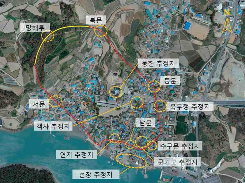
전라우수영 배치도[1]

참고자료
- 『조선시대 수군진조사 I - 전라우수영 편』, 국립해양문화재연구소, 2011.
주석
- ↑ 『조선시대 수군진조사 I - 전라우수영 편』, 국립해양문화재연구소, 2011, 59쪽.