창원 진해 웅천읍성
| 창원 진해 웅천읍성 Uncheoneupseong Walled Town, Changwon |
|
 창원 진해 웅천읍성, 창원시문화관광, 창원시청. |
|
| 대표명칭 | 창원 진해 웅천읍성 |
|---|---|
| 영문명칭 | Uncheoneupseong Walled Town, Changwon |
| 한자 | 昌原 鎭海 熊川邑城 |
| 주소 | 경상남도 창원시 진해구 성내동 519-6 |
| 지정(등록) 종목 | 경상남도 기념물 제15호 |
| 지정(등록)일 | 1974년 12월 28일 |
| 분류 | 유적건조물/정치국방/성/성지 |
| 수량/면적 | 일곽 |
| 웹사이트 | 창원 진해 웅천읍성, 국가문화유산포털, 문화재청. |
|
|
|
해설문
국문
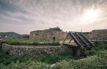
태종 7년(1407)에 개항한 웅천의 내이포는 일본과 무역을 하던 곳이었다. 그러나 불법 거주하는 일본인의 수가 늘어나자 고을을 보호하기 위해 세종(1418~1450) 대에 와서 웅천읍성*을 지었다. 중종 5년(1510)에는 삼포왜란으로 동문이 함락되어 소실되기도 하였고, 임진왜란 때는 왜군이 주둔하던 웅천왜성에 딸린 성으로 사용되기도 하였다. 오랜 기간 남해안을 방어하는 주요 거점으로 사용되었으나 고종 32년(1895) 읍성으로서의 기능을 상실한 것으로 보인다.
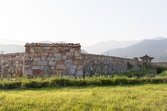
웅천읍성은 세종 이후 여러 차례 고쳐 지었는데 그 과정에서 평면 모양이 정사각형에서 현재와 같이 직사각형으로 바뀌었다. 읍성의 전체 둘레는 936m로 현재 남아 있는 길이는 약 500m이며, 성벽의 폭은 4.5m, 높이는 4.4m이다. 성벽은 땅과 수직이 되도록 쌓았으며 큰 돌 사이사이에 작은 돌들을 끼워 넣었다.
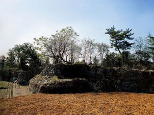
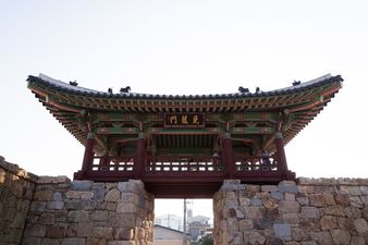
북쪽 성벽은 진해-부산 간 국도를 건설하면서 철거되었고, 서쪽 성벽과 남쪽 성벽은 민가와 도로 등이 들어서면서 일부 훼손되어 동쪽 성벽만 출입문 터와 함께 온전히 남아 있다.
- 읍성(邑城): 관청과 민가를 비롯한 고을 중심부를 둘러 쌓은 성으로, 지방 군현의 주민을 보호하고 군사적, 행정적 기능을 담당하였다.
영문
Uncheoneupseong Walled Town, Changwon
A walled town, called eupseong in Korean, was established at an important location in an area to protect residents and serve military and administrative functions.
This walled town was located near Naeipo Port which was opened in 1407 for trade with Japan. The walled town was built during the reign of King Sejong (r. 1418-1450) to protect the area from the increasing number of illegal settlers from Japan. During riots organized by the Japanese residents in 1510, the fortress was briefly captured, and its eastern gate was destroyed. During the Japanese invasion of 1592, it was used by the Japanese troops as an auxiliary fortress of their main fortress in Ungcheon. The walled town served as an important stronghold protecting the southern coast of Korea until 1895 when a new military system was implemented.
The walled town originally measured 936 m in perimeter, but only about 500 m of the wall remains. The walls measure 4.5 m in depth and 4.4 m in height. They were built perpendicularly to the ground and feature a combination of large and small stones. Through a number of renovations and reconstructions over time, the fortress’s shape changed from square to rectangular. The northern part of the wall was demolished during the construction of the road connecting Jinhae and Busan. The western and the southern parts of the wall were also significantly damaged by the expansion of the adjacent residential area and road. Only the eastern section of the wall with its gate remain intact.
영문 해설 내용
읍성이란 지방 주요 지역에 쌓은 성으로, 지방 주민들을 보호하고 군사, 행정 기능을 담당하던 곳이다.
웅천읍성이 있는 내이포는 원래 1407년에 개항하여 일본과 무역을 하던 곳이다. 그러나 불법 거주하는 일본인의 수가 늘어나자, 일본인들로부터 고을을 보호하기 위해 세종(1418~1450 재위) 때에 읍성을 지었다. 1510년에는 왜란으로 함락되어 동문이 소실되기도 하였고, 임진왜란 때에는 왜군이 주둔하던 웅천왜성에 딸린 성으로 사용되기도 하였다. 오랜 기간 남해안을 방어하는 주요 거점으로 사용되었으며, 읍성으로서의 기능은 갑오개혁 이후인 1895년 상실된 것으로 보인다.
읍성의 전체 둘레는 원래 936m였으나, 현재 남아 있는 길이는 약 500m이고, 성벽의 폭은 4.5m, 높이는 4.4m 이다. 성벽은 땅과 수직이 되도록 쌓았으며, 큰 돌 사이사이에 작은 돌들을 끼웠다. 여러 차례 고쳐 지으면서, 평면 모양이 정사각형에서 직사각형으로 바뀌었다. 북쪽 성벽은 진해-부산간 국도를 건설하면서 철거되었고, 서쪽과 남쪽 성벽은 후대에 민가와 도로 등이 들어서면서 일부 훼손되어, 동쪽 성벽만 문터와 함께 온전히 남아 있다.
갤러리
참고자료
- 창원 진해 웅천읍성, 두산백과. https://terms.naver.com/entry.naver?docId=1195396&cid=40942&categoryId=33084
- 창원 진해 웅천읍성, 국가문화유산포털, 문화재청. http://www.heritage.go.kr/heri/cul/culSelectDetail.do?ccbaCpno=2333800150000
- 웅천읍성지, 한국민족문화대백과사전, 한국학중앙연구원. http://encykorea.aks.ac.kr/Contents/Item/E0040560
- 웅천읍성지, 디지털창원문화대전, 한국학중앙연구원. http://changwon.grandculture.net/changwon/toc/GC02206230
- 노재헌, 김갑진, 「진해 웅천읍성 발굴조사 개보」, 『한국성곽학회』, 2008.11, 73~117쪽.


