Mao Kun Explorer
red
목차
Who 누가
총책임연구자: Ryan Carpenter
조력자
- Anthony Barbeiri: 영감 제공, 지도 스캔본 이미지 타일링
- Aaron Jia-rong CHEN (陈佳荣): 南溟網(South Seas Network)의 명청시대 동남아시아 및 인도양 지도 백과사전 카탈로그 편집, 동료 Jianqiu ZHU (朱鑒秋)의 메모 공유
- Sheng-I HSU (徐勝一): 지구의 세차운동을 통해 정화의 카말 측정치가 현대와 일치하지 않는 이유를 설명, 북극성이 보이지 않는 아프리카 남동부와 몰디브에서 항성 관측과 관련된 제작자의 질문 해결
- José Manuel Malhão Pereira: 15세기 선원들이 사용했던 항해 도구의 용도 규명, 포르투갈어에서 영어로 변역
- Sally K. Church: 제작 과정에서 발생하는 질문 해결, JVG Mills의 연구에 대한 이해 보조
- Reddit 사용자(cabaran, rankwally, ralmin, Time_Swallow, treyparkermattstone, Rogerinplay, soowhooh, houseforever): 사이트, 용어집을 중국어로 번역
When 언제
2021년 12월 11일[1]
Where 어디서
홍콩[2]
What 무엇을
정화 대항해[3]
- 정화
- 목적
- 항해 과정
- 1차 항해
- 2차 항해
- 3차 항해
- 4차 항해
- 5차 항해
- 6차 항해
- 7차 항해
- 의의
정화의 탐험은 명나라 시조의 아들인 영락제에 의해 1403년에 처음 명령되었다. 총 7개의 주요 탐험이 이루어졌고 1433년에 끝이 났다. 그 직후에 항해를 묘사한 여러 권의 책이 출판되었지만, 이 지도는 오늘날까지 남아있고, 거의 200년이 지나서야, Wubei Zhi라는 책의 일부로 편집되었습니다.
Zheng He's expeditions were first ordered in 1403 by the Yongle Emperor, the son of the founder of the Ming Dynasty. In all, seven major expeditions were made, ending in 1433. Several books describing the voyages were published in their immediate aftermath, but this map, as it survives today, wasn't compiled until almost 200 years later, as part of the book Wubei Zhi.
How 어떻게
React
Leaflet
GeoJSON
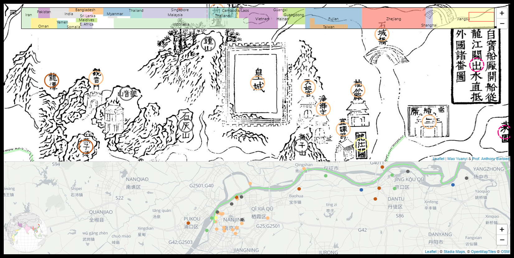
I created a map editing tool in React.js and Leaflet.js. I advertised it in various online communities interested in Chinese history, in order to crowd-source the transcription and translation of the map. Volunteers click on a map label, then enter its text, translation, and (if known) modern name in a small form. In this way, all 551 plotted locations were transcribed, along with a few dozen long strings of navigation instructions. I researched many historical references to identify as many locations as possible, including latitude and longitude of each point.
With this data compiled, I generated a geoJSON file with all the details to plot on both the Mao Kun map and a modern projection of the globe. In the "explore" version of the website, these maps are presented one above the other. Dragging the Mao Kun map causes the modern map to automatically pan toward the equivalent view. Clicking on a marker in one map, highlights its twin in the other. Each marker links to Wikipedia articles related to the place in question.
At the top, a colorful mini-map shows the entire Mao Kun map at once, with colors corresponding to the borders of modern provinces and nations.
React.js와 Leaflet.js에서 지도 편집 도구를 만들었습니다. 중국 역사에 관심이 있는 다양한 온라인 커뮤니티에 이 지도를 크라우드소싱하기 위해 광고를 했습니다. 자원봉사자는 지도 라벨을 클릭한 후 텍스트, 번역 및 (알고 있는 경우) 현대 이름을 작은 형식으로 입력합니다. 이 방법으로 551개의 표시된 모든 위치가 수십 개의 긴 항법 설명과 함께 기록되었습니다. 나는 각 지점의 위도와 경도를 포함하여 가능한 한 많은 위치를 확인하기 위해 많은 역사적 참고 자료를 조사했다.
이 데이터를 취합하여 GeoJ를 생성했습니다.SON 파일에는 마오쿤 지도와 지구의 현대 투영에 대한 모든 세부 정보가 포함되어 있습니다. 웹 사이트의 "탐색" 버전에서는 이러한 맵이 차례로 표시됩니다. 마오쿤 지도를 끌면 현대 지도가 자동으로 동일한 뷰로 이동합니다. 한 지도에서 마커를 클릭하면 다른 지도에서 마커가 강조 표시됩니다. 각 마커는 해당 장소와 관련된 위키피디아 기사에 링크됩니다.
맨 위에는 마오쿤 지도 전체를 한 번에 보여주는 화려한 미니맵이 있으며, 그 색상은 현대의 지방과 국가의 경계에 대응하고 있다.
지도는 오른쪽에서 왼쪽으로 읽힌다. 난징의 황궁에서 출발해 양쯔강을 따라 해안으로 향하다가 말레이 반도를 따라 남쪽으로 향하며 대양을 건너 인도를 지나 호르무즈 섬으로 향한다. 아프리카 해안은 지도의 맨 아래를 따라 두 배로 돌아가 모잠비크까지 닿는다. 이 모든 영역은 한 권의 두루마리 또는 20페이지 분량의 책에 목판 인쇄될 수 있는 길고 좁은 지도에 왜곡되고 압축되어 있다.
마오쿤 지도 (A4 페이지 20) 이 맵에 표시되는 데이터는 CSV 및 GeoJSON 형식으로 사용할 수 있습니다. GeoJSON에는 2가지 버전이 있습니다.하나는 위도와 경도가 불분명한 경우에도 모든 위치를 포함하며, 다른 하나는 확인되지 않은 위치를 제외합니다. 이는 플랫폼에 따라 문제가 될 수 있기 때문입니다.
The map is read from right to left (as is the Chinese text). Starting from the imperial palace in Nanjing, it follows the Yangtze River to the coast, heads south around the Malay Peninsula and crosses the ocean, past India to the island of Hormuz. The coast of Africa doubles back along the bottom of the map, reaching all the way to Mozambique. All this territory is contorted and compressed into a long, narrow map that could be woodblock-printed onto a single scroll or twenty pages of a book.
Mao Kun Map on 20 A4 pages The data displayed in this map is available in CSV and GeoJSON formats, if you'd like to use it for another project. There are two versions of the GeoJSON: one includes all locations, even if latitude and longitude are unidentified and the other excludes unidentified locations, since they can be a problem on some platforms.
Why 왜
명나라 정화의 항해에 바탕을 두고 있는 마오쿤 지도는 중국 밖의 세계의 모습을 보여주는 가장 오래된 중국 문서이다. 그 의의가 작지 않음에도 사용하기 어렵다는 한계를 인식한 연구자는 이미지 타일과 디지털 매핑 기술을 활용해 웹사이트를 개발해 그 한계를 극복하고자 하였다.
Comment 논평
(내용 작성)
References 각주
- ↑ 연구와 관련해서 찾을 수 있었던 유일한 날짜 https://github.com/carpiediem/maokun-explorer
- ↑ 본인 소개 홈페이지에도 홍콩이라고만 명시되어 있다. 현 직장 주소는: 111 Queen's Rd W, Sheung Wan, Hong Kong 20/F, Hua Fu Commercial Building, HK Hong Kong Hong Kong, Singapore, United States 0000
- ↑ 최형록.(2011).정화(鄭和) 대항해와 해양 국가 및 해양 도시와의 교류 연구.해항도시문화교섭학,(5),133-161.

