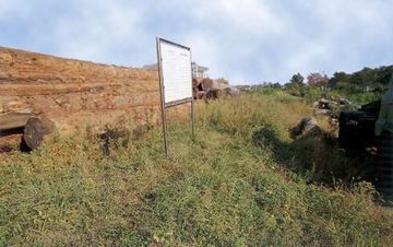
경주 남고루
| 경주 남고루 Namgoru Embankment, Gyeongju |
|
 경주 남고루, 국가문화유산포털, 문화재청. |
|
| 대표명칭 | 경주 남고루 |
|---|---|
| 영문명칭 | Namgoru Embankment, Gyeongju |
| 한자 | 慶州 南古壘 |
| 주소 | 경상북도 경주시 황오동 21-1 |
| 지정(등록) 종목 | 사적 제17호 |
| 지정(등록)일 | 1963년 1월 21일 |
| 분류 | 유적건조물/정치국방/성/성곽시설 |
| 수량/면적 | 41,743㎡ |
| 웹사이트 | 경주 남고루, 국가문화유산포털, 문화재청. |
|
|
|
해설문
국문
남고루는 대릉원의 남쪽 입구에서부터 동쪽으로 황오동 고분군을 돌아 북쪽의 북천까지 이어진 토루(土壘)*이다. 시가지가 확대되면서 대부분 흔적 없이 파괴되었고, 경주고등학교 서쪽을 지나는 일부만이 남아 있다.
『고려사절요(高麗史節要)』에 고려 현종 3년(1012) 8월에 세웠다는 기록이 있고, 『동경잡기(東京雜記)』에는 현종 때 전라, 충청, 경상 3도의 군졸을 동원하여 북천에 돌을 쌓아 제방(堤防)을 만들었다는 기록이 있다.
1993년에 남고루의 일부를 발굴조사한 결과 토루 아래층에서 통일신라시대 도로유적과 성벽의 기초 석축, 해자(垓子)* 등이 확인되어 고려시대에 쌓은 읍성의 외성일 가능성도 가지고 있다.
- 토루(土壘): 적의 침입을 막기 위해 흙으로 쌓은 제방이나 둑, 보루(堡壘)
- 해자(垓子): 적의 침입을 막기 위해 성 밖을 둘러 파서 못으로 만든 곳. 굴강(掘江)·외호(外濠)·성호(城濠)
영문
Namgoru Embankment, Gyeongju
These are the remains of an earthen embankment. It is uncertain when it was first constructed, but it is believed that it was built during the Goryeo period (918-1392) to prevent flooding of a walled town. A walled town, called eupseong in Korean, was established at an important location in an area to protect residents and serve military and administrative functions.
The embankment was mostly destroyed due to the development of the city center and only some of it remains today, such as the part to the west of Gyeongju High School. It is presumed to have originally stretched from the southern entrance of Daereungwon Ancient Tomb Complex, passing by the ancient tombs in Hwango-dong in the east, and then up to Bukcheon Stream in the north.
An excavation conducted in 1993 revealed various remains at the lower level of the earthen embankment, such as a road, the foundation of a fortress wall, and a moat dating to the Unified Silla period (668-935). Based on these discoveries, other theories suggest that the embankment may have been built as an outer wall of the walled town for defensive purposes.
영문 해설 내용
남고루는 흙으로 쌓은 제방이다. 언제 처음 만들어졌는지 확실히는 알 수 없으며, 고려시대에 읍성의 수해를 막기 위해 쌓은 것으로 추정된다. 읍성이란 지방 주요 지역에 쌓은 성으로, 지방 주민들을 보호하고 군사, 행정 기능을 담당하던 곳이다.
원래의 제방은 시가지가 개발되면서 대부분 파괴되었고, 지금은 경주고등학교 서쪽 등 일부에만 흔적이 남아 있다. 과거에는 대릉원 남쪽 입구에서부터 동쪽으로 황오동 고분군을 돌아 북쪽의 북천까지 이어졌던 것으로 보인다.
1993년 일부 구간을 발굴조사 결과, 토루 아래층에서 통일신라시대 도로유적, 성벽의 기초 석축, 해자 등이 확인되었다. 이러한 발견을 토대로, 이 토루가 적의 침입을 막기 위해 읍성 밖에 두른 외성이었을 가능성도 제기되고 있다.