"Korean History as Seen through Maps"의 두 판 사이의 차이
| (다른 사용자 한 명의 중간 판 하나는 보이지 않습니다) | |||
| 2번째 줄: | 2번째 줄: | ||
|Article=지도로 보는 한국 역사 | |Article=지도로 보는 한국 역사 | ||
}} | }} | ||
| + | |||
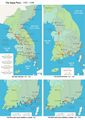
| + | The maps below show the history of the Korean peninsula by historical time period - including Gojoseon, the Three Kingdoms period, the Northern and Southern States period, Goryeo, Joseon, the Japanese Occupation period, post-liberation, and today. Through this, you can gain an overview of the Korean peninsula over time. In particular, through the inclusion of maps which detail events such as the Japanese invasions of Korea (1592-1598), the anti-Japan movement during the colonial occupation period, and the Korean War, you can raise your understanding of key events which occurred on the Korean peninsula. | ||
| + | |||
| + | =='''Maps of Korea by Historic Period'''== | ||
| + | <gallery> | ||
| + | File:001(E).jpg|Gojoseon | ||
| + | File:002(E).jpg|Proto Three Kingdoms | ||
| + | File:003(E).jpg|Three Kingdoms - Late 4CE-Early 5CE | ||
| + | File:004(E).jpg|Three Kingdoms - Late 5CE-Early 6CE | ||
| + | File:005(E).jpg|Three Kingdoms - Mid 6CE-Early 7CE | ||
| + | File:006(E).jpg|Northern and Southern States Period | ||
| + | File:007(E).jpg|Goryeo | ||
| + | File:008(E).jpg|Joseon | ||
| + | File:009(E).jpg|Japanese Occupation Period | ||
| + | File:010(E).jpg|Post-Liberation, Korean War Period | ||
| + | File:011(E).jpg|South Korea | ||
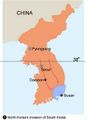
| + | File:012(E).jpg|North Korea | ||
| + | </gallery> | ||
| + | |||
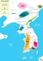
| + | =='''Maps of Korea's Major Historic Sites'''== | ||
| + | <gallery> | ||
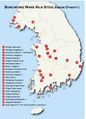
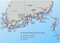
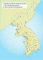
| + | File:013(E).jpg|Bronze Dagger Sites | ||
| + | File:014(E).jpg|Dolmen Sites | ||
| + | File:015(E).jpg|Major Paleolithic Sites | ||
| + | 파일:022(E).jpg|Major Sites of Celedon Production | ||
| + | 파일:041(E).jpg|Sites of Buncheong Production | ||
| + | 파일:045(E).jpg|Locations of Joseon Royal Tombs | ||
| + | 파일:046(E).jpg|Locations of Seoul's Main Palaces | ||
| + | </gallery> | ||
| + | |||
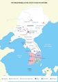
| + | =='''The Imjin War as Seen through Maps'''== | ||
| + | <gallery> | ||
| + | File:023(E).jpg|Imjin War | ||
| + | File:023-2(E).jpg|Primary Routes of the Japanese Invasion | ||
| + | File:044(E).jpg|The Joseon Navy Protecting Joseon on the Sea | ||
| + | </gallery> | ||
| + | |||
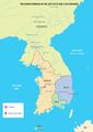
| + | =='''The Korean War as Seen through Maps'''== | ||
| + | <gallery> | ||
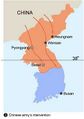
| + | File:018(E).jpg|North Korea's Invasion of South Korea | ||
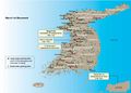
| + | File:019(E).jpg|Participation of the United Nations Army | ||
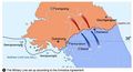
| + | File:020(E).jpg|Chinese Army's Intervention | ||
| + | File:021(E).jpg|The Military Line Set up Accordidng to the Amistice Agreement | ||
| + | </gallery> | ||
| + | |||
| + | =='''The Anti-Japanese Movement as Seen through Maps'''== | ||
| + | <gallery> | ||
| + | File:032(E).jpg|March First Independence Movement | ||
| + | File:032-2(E).jpg|March First Independence Movement | ||
| + | </gallery> | ||
[[Category:Korea as Seen through Multimedia]] | [[Category:Korea as Seen through Multimedia]] | ||
2017년 12월 26일 (화) 13:00 기준 최신판
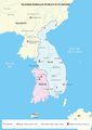
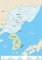
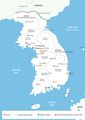
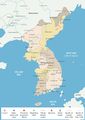
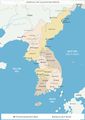
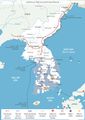
The maps below show the history of the Korean peninsula by historical time period - including Gojoseon, the Three Kingdoms period, the Northern and Southern States period, Goryeo, Joseon, the Japanese Occupation period, post-liberation, and today. Through this, you can gain an overview of the Korean peninsula over time. In particular, through the inclusion of maps which detail events such as the Japanese invasions of Korea (1592-1598), the anti-Japan movement during the colonial occupation period, and the Korean War, you can raise your understanding of key events which occurred on the Korean peninsula.
목차
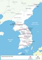
Maps of Korea by Historic Period
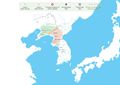
Gojoseon
Proto Three Kingdoms
Three Kingdoms - Late 4CE-Early 5CE
Three Kingdoms - Late 5CE-Early 6CE
Three Kingdoms - Mid 6CE-Early 7CE
Northern and Southern States Period
Goryeo
Joseon
Japanese Occupation Period
Post-Liberation, Korean War Period
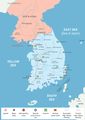
South Korea
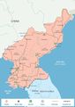
North Korea
.jpg)
.jpg)
.jpg)
.jpg)
.jpg)
.jpg)
.jpg)
.jpg)
.jpg)
.jpg)
.jpg)
.jpg)
Maps of Korea's Major Historic Sites
Bronze Dagger Sites
Dolmen Sites
Major Paleolithic Sites
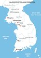
Major Sites of Celedon Production
Sites of Buncheong Production
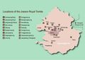
Locations of Joseon Royal Tombs
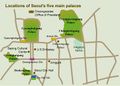
Locations of Seoul's Main Palaces
.jpg)
.jpg)
.jpg)
.jpg)
.jpg)
.jpg)
.jpg)
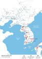
The Imjin War as Seen through Maps
Imjin War
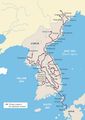
Primary Routes of the Japanese Invasion
The Joseon Navy Protecting Joseon on the Sea
.jpg)
.jpg)
.jpg)
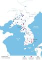
The Korean War as Seen through Maps
North Korea's Invasion of South Korea
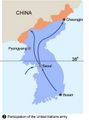
Participation of the United Nations Army
Chinese Army's Intervention
The Military Line Set up Accordidng to the Amistice Agreement
.jpg)
.jpg)
.jpg)
.jpg)
The Anti-Japanese Movement as Seen through Maps
March First Independence Movement
March First Independence Movement
.jpg)
.jpg)