"보가산성지"의 두 판 사이의 차이
(→영문) |
(→영문) |
||
| 34번째 줄: | 34번째 줄: | ||
'''Bogasanseong Fortress Site''' | '''Bogasanseong Fortress Site''' | ||
| − | + | These are the remains of a stone fortress located near a major stream flowing down the western slope of Bogaesan Mountain. The fortress is presumed to date to the 10th century. | |
| − | + | According to legend, Gungye (?-918), the founder of the Taebong kingdom (901-918), hurriedly built this fortress while on the run from Wang Geon (877-943), who eventually took over the kingdom and renamed it Goryeo (918-1392). Many artifacts excavated from the site date to the mid-Goryeo period, suggesting that the fortress was used again during the Mongol invasions (1231-1259). According to records, it was used at least until 1530 during the Joseon period (1392-1910), and no longer existed for certain by 1908. | |
| − | + | The fortress has a diamond shape, measuring over twice as long north-to-south as east-to-west. | |
| + | Cliffs in the north and east were utilized to serve as natural walls, while stone walls were built in the south and west. The stone walls consisted of an inner wall and outer wall, measuring 327 m and 4.2 km in length, respectively. Most sections of the wall have collapsed, and the longest remaining contiguous section measures 75 m in length. | ||
| − | + | In addition to excavated artifacts, the remains of a gate site, a well, and two presumed building sites were found within the fortress premises. | |
| + | *http://blog.daum.net/tt620/600 | ||
| + | *http://blog.daum.net/yoonbinahn/7998378 | ||
| + | |||
| + | |||
| + | *'''보개산(寶蓋山) 능선 서쪽 계곡을 따라 안쪽과 바깥쪽에 이중으로 쌓은 산성이다''' | ||
| + | **이 표현은 이해하기 매우 어려운 것 같아요. | ||
| + | *성벽이 있는 부분은 4.2km인지, 절벽 포함 전체 둘래가 4.2km인지 확인 필요. | ||
*국문은 너무 헷갈리게 써서 번역은 아주 이상하게 나왔어요. 이렇게 수정해야 말이 되는 건 아닌가요... | *국문은 너무 헷갈리게 써서 번역은 아주 이상하게 나왔어요. 이렇게 수정해야 말이 되는 건 아닌가요... | ||
**'''돌로 쌓은 산성 대부분이 무너져 내렸지만, 서쪽과 북쪽 성벽은 일부 남아 있다. 동쪽과 남쪽은 절벽으로 이루어져 성벽을 쌓지 않았다.''' ---> 동쪽과 남쪽은 절벽으로 이루어져 성벽을 쌓지 않았다. 서쪽과 북쪽 성벽은 돌로 쌓았으나 대부분이 무너져 내려서 일부만 남아 있다. | **'''돌로 쌓은 산성 대부분이 무너져 내렸지만, 서쪽과 북쪽 성벽은 일부 남아 있다. 동쪽과 남쪽은 절벽으로 이루어져 성벽을 쌓지 않았다.''' ---> 동쪽과 남쪽은 절벽으로 이루어져 성벽을 쌓지 않았다. 서쪽과 북쪽 성벽은 돌로 쌓았으나 대부분이 무너져 내려서 일부만 남아 있다. | ||
2020년 7월 12일 (일) 18:31 판
| 보가산성지 |
|
| 대표명칭 | 보가산성지 |
|---|---|
| 한자 | 保架山城址 |
| 주소 | 경기도 포천시 관인면 중리 산251-1 |
| 지정번호 | 포천시 향토유적 제36호 |
| 지정일 | 1986년 4월 9일 |
| 소유자 | 사유 |
|
|
|
해설문
국문
보개산(寶蓋山) 능선 서쪽 계곡을 따라 안쪽과 바깥쪽에 이중으로 쌓은 산성이다. 산 이름을 따서 ‘보개산성’이라 하기도 한다.
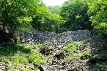
성의 규모는 전체 길이가 약 4,495m(외성 4,168m, 내성 327m)로, 비교적 큰 성에 속한다. 돌로 쌓은 산성 대부분이 무너져 내렸지만, 서쪽과 북쪽 성벽은 일부 남아 있다. 동쪽과 남쪽은 절벽으로 이루어져 성벽을 쌓지 않았다.
포천과 철원 일대에 있는 여러 산성과 마찬가지로, 보가산성 역시 궁예(弓裔, ?~918)와 관련된 전설을 지니고 있다. 궁예가 왕건(王建, 847~918)에게 왕위를 빼앗기고 쫓길 때에 반격의 거점으로 삼아 쌓은 성이라는 것이다. 그리하여 ‘궁예왕 성터’라 하거나, ‘궁예왕 대궐 터’ 또는 ‘궁예왕 우물 터’라 불리고 있다.
지표조사 결과 고려 중기 유물이 주로 수습된 것으로 보아, 몽고와의 전쟁 때에 주로 사용된 산성으로 추정된다.
영문
Bogasanseong Fortress Site
These are the remains of a stone fortress located near a major stream flowing down the western slope of Bogaesan Mountain. The fortress is presumed to date to the 10th century.
According to legend, Gungye (?-918), the founder of the Taebong kingdom (901-918), hurriedly built this fortress while on the run from Wang Geon (877-943), who eventually took over the kingdom and renamed it Goryeo (918-1392). Many artifacts excavated from the site date to the mid-Goryeo period, suggesting that the fortress was used again during the Mongol invasions (1231-1259). According to records, it was used at least until 1530 during the Joseon period (1392-1910), and no longer existed for certain by 1908.
The fortress has a diamond shape, measuring over twice as long north-to-south as east-to-west. Cliffs in the north and east were utilized to serve as natural walls, while stone walls were built in the south and west. The stone walls consisted of an inner wall and outer wall, measuring 327 m and 4.2 km in length, respectively. Most sections of the wall have collapsed, and the longest remaining contiguous section measures 75 m in length.
In addition to excavated artifacts, the remains of a gate site, a well, and two presumed building sites were found within the fortress premises.
- 보개산(寶蓋山) 능선 서쪽 계곡을 따라 안쪽과 바깥쪽에 이중으로 쌓은 산성이다
- 이 표현은 이해하기 매우 어려운 것 같아요.
- 성벽이 있는 부분은 4.2km인지, 절벽 포함 전체 둘래가 4.2km인지 확인 필요.
- 국문은 너무 헷갈리게 써서 번역은 아주 이상하게 나왔어요. 이렇게 수정해야 말이 되는 건 아닌가요...
- 돌로 쌓은 산성 대부분이 무너져 내렸지만, 서쪽과 북쪽 성벽은 일부 남아 있다. 동쪽과 남쪽은 절벽으로 이루어져 성벽을 쌓지 않았다. ---> 동쪽과 남쪽은 절벽으로 이루어져 성벽을 쌓지 않았다. 서쪽과 북쪽 성벽은 돌로 쌓았으나 대부분이 무너져 내려서 일부만 남아 있다.
