"나주 영산포 자기수위표"의 두 판 사이의 차이
Mkichukova (토론 | 기여) (→영문) |
|||
| 34번째 줄: | 34번째 줄: | ||
===영문=== | ===영문=== | ||
'''Water Gauge in Yeongsanpo, Naju''' | '''Water Gauge in Yeongsanpo, Naju''' | ||
| + | |||
| + | This water gauge was constructed in 1915, during the Japanese colonial period (1910-1945), to observe the water of Yeongsangang River and to be used as a lighthouse. | ||
| + | |||
| + | Yeongsanpo, which is located in the depth of Yeongsangang River, was Honam's first inland port where many ships came to load and exchange various products from the area. During the Japanese colonial period, the Japanese bestowed Yeongsanpo as a hub for exporting rice from the fields of Naju, so they built this water gauge and observed the water of Yeongsangang River. They used concrete which was used as a construction material at the time, and a lamp was installed above the roof. The ships that came and go understood that they have accessed Yeongsanpo ferry dock by looking at it, so it was also named "Yeongsanpo Lighthouse". | ||
| + | |||
| + | According to a Korean territory development plan from 1970-1980, land and railroads were utilized, so the creek bank of Yeongsangang River was constructed and the water dropped. After this, ships no longer accessed Yeongsanpo and this water gauge was destroyed in 1989. In 2004, it was listed as National Registered Cultural Heritage as it is a modern cultural heritage symbolizing the former style of the waterways of Yeongsangang River and the export by the colonial authorities. | ||
===영문 해설 내용=== | ===영문 해설 내용=== | ||
2020년 11월 19일 (목) 14:39 판
| 나주 영산포 자기수위표 Water Gauge in Yeongsanpo, Naju |
|
 나주 영산포 자기 수위표, 국가문화유산포털, 문화재청. |
|
| 대표명칭 | 나주 영산포 자기수위표 |
|---|---|
| 영문명칭 | Water Gauge in Yeongsanpo, Naju |
| 한자 | 羅州 榮山浦 自記水位標 |
| 주소 | 전라남도 나주시 영산동 659-3 |
| 지정번호 | 국가등록문화재 제129호 |
| 지정일 | 2004년 12월 31일 |
| 분류 | 등록문화재/기타/공공용시설 |
| 시대 | 일제강점기 |
| 수량/면적 | 1동, 높이 8.65m, 면적 6.1㎡ |
| 웹사이트 | 나주 영산포 자기 수위표, 국가문화유산포털, 문화재청. |
|
|
|
해설문
국문
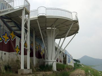
영산포 자기 수위표는 해상 교역에서 중요한 역할을 했던 영산포 선창에 건립한 산업 시설물이다. 영산강 깊숙한 곳에 자리 잡은 영산포는 과거 내륙 속의 바다로 수많은 배들이 드나들던 포구였다. 이곳에 포구가 생기기 전에는 둥구 나루라 하여 조금 떨어진 곳에 포구가 있었다. 일제 강점기 때에 일본은 나주 평야의 쌀을 수탈하기 위하여 식민지 전진 기지로 이 영산포를 선정하고, 1915년에 영산강의 수위를 관측하기 위해 이 시설물을 세웠다. 당시로는 귀한 건축 자재인 콘크리트를 사용하였다. 수위 관측소 지붕 위에 전등을 달았는데, 오고 가는 배들이 이를 보고 영산포구에 왔다는 인식을 하게 되어 일명 “영산포 등대”라고 부르기도 하였다.
자기 수위표는 『한국 수문 조사서』의 ‘영산포 자기 수위표 구조도’ 설계 도면에서 확인할 수 있으며, 1929년에 촬영한 내외부 사진에서 자기 수위계*를 설치한 것을 확인할 수 있다.
영산강 뱃길 역사의 한 단면을 보여주는 영산포 자기 수위표는 일제에 의한 내륙 수탈의 상징적인 산업 구조물로 영산포에 남아 있는 근대 문화유산의 하나이다.
- 자기 수위계(自記水位計): 저수지 · 배수지(配水池)의 수심이나 하천의 수위를 나타내는 도구로 부표를 띄우고 수위의 오르내림을 스스로 기록하는 장치
영문
Water Gauge in Yeongsanpo, Naju
This water gauge was constructed in 1915, during the Japanese colonial period (1910-1945), to observe the water of Yeongsangang River and to be used as a lighthouse.
Yeongsanpo, which is located in the depth of Yeongsangang River, was Honam's first inland port where many ships came to load and exchange various products from the area. During the Japanese colonial period, the Japanese bestowed Yeongsanpo as a hub for exporting rice from the fields of Naju, so they built this water gauge and observed the water of Yeongsangang River. They used concrete which was used as a construction material at the time, and a lamp was installed above the roof. The ships that came and go understood that they have accessed Yeongsanpo ferry dock by looking at it, so it was also named "Yeongsanpo Lighthouse".
According to a Korean territory development plan from 1970-1980, land and railroads were utilized, so the creek bank of Yeongsangang River was constructed and the water dropped. After this, ships no longer accessed Yeongsanpo and this water gauge was destroyed in 1989. In 2004, it was listed as National Registered Cultural Heritage as it is a modern cultural heritage symbolizing the former style of the waterways of Yeongsangang River and the export by the colonial authorities.
영문 해설 내용
이 수위표는 일제강점기 때인 1915년 영산강의 수위를 관측하고 등대로도 사용하기 위해 건립하였다.
영산강 깊숙한 곳에 자리 잡은 영산포는 수많은 배들이 온갖 지역의 산물을 싣고 와서 교류하던 호남 제일의 내륙항이었다. 일제강점기 때에 일본은 나주 평야의 쌀을 수탈하기 위하여 영산포를 거점으로 선정하고, 이 수위표를 세워 영산강의 수위를 관측하였다. 당시로는 귀한 건축 자재인 콘크리트를 사용하였고, 지붕 위에는 전등을 달았다. 오고 가는 배들이 이를 보고 영산포구에 왔다는 인식을 하게 되어 일명 “영산포 등대”라고 부르기도 하였다.
1970-1980년대 국토 개발 계획에 따라 육로와 철로가 발달하였고, 영산강 하구둑이 준공되면서 수위가 낮아졌다. 이후 영산포에는 더이상 배가 드나들지 않게 되면서 이 수위표는 1989년 폐쇄되었다. 영산강 뱃길의 옛 모습과 일제의 수탈을 상징하는 근대 문화유산으로 2004년 국가등록문화재로 등록되었다.