"금사동 토성"의 두 판 사이의 차이
잔글 |
|||
| 28번째 줄: | 28번째 줄: | ||
'''Geumsadongtoseong Earthen Fortification''' | '''Geumsadongtoseong Earthen Fortification''' | ||
| − | This mountain fortress surrounds | + | This mountain fortress surrounds Geumsadong Valley, located to the north of Eungbongsan Mountain. It is presumed to have been built during the Baekje period (18 BCE–660 CE). |
The fortress measures 2.4 km in perimeter, 170 m in diameter from east to west and 620 m from north to south. It is comprised of an inner and outer section, which is typical of fortresses found in the former site of the Baekje Kingdom. Traces of three water drainage and a gate were discovered in the northern area of the fortress. In the southern area, there remains a site of entrance. Inside the fortress were discovered a flat ground presumed as a building site and three sites of springs, along with some shards of pottery from the Baekje period. | The fortress measures 2.4 km in perimeter, 170 m in diameter from east to west and 620 m from north to south. It is comprised of an inner and outer section, which is typical of fortresses found in the former site of the Baekje Kingdom. Traces of three water drainage and a gate were discovered in the northern area of the fortress. In the southern area, there remains a site of entrance. Inside the fortress were discovered a flat ground presumed as a building site and three sites of springs, along with some shards of pottery from the Baekje period. | ||
2020년 6월 18일 (목) 22:36 판
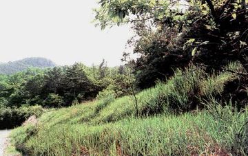
| 금사동토성 Geumsadongtoseong Earthen Fortification |
|
 금사동 토성, 국가문화유산포털, 문화재청. |
|
| 대표명칭 | 금사동토성 |
|---|---|
| 영문명칭 | Geumsadongtoseong Earthen Fortification |
| 한자 | 金寺洞土城 |
| 주소 | 전북 정읍시 영원면 은선리 26번지 |
| 지정번호 | 전라북도 기념물 제55호 |
| 지정일 | 1981년 4월 1일 |
| 분류 | 유적건조물/정치국방/성/성곽 |
| 수량/면적 | 355,396㎡ |
| 웹사이트 | 금사동 토성, 국가문화유산포털, 문화재청. |
|
|
|
해설문
국문
금사동 토성은 정읍시 영원면 은선리와 고부면 장문리를 경계 짓는 응봉산 북쪽 계곡을 에워싸고 있는 산성이다. 성의 이름은 골짜기의 이름인 금사동을 따서 지었다. 북쪽 골짜기에 성문터와 수구가 있으며, 남쪽 중앙에는 문터가 남아 있다. 성안에는 건물터와 3곳이나 되는 샘터가 있다. 또한 백제시대 것으로 보이는 그릇 조각들이 흩어져 있다. 금사동 토성은 성의 둘레가 2,365m에 달한다. 동서의 길이가 170m이고 남북 길이는 620m인데 남쪽은 산 능선을 따라 돌로 쌓아 올렸다. 동쪽 가운데에는 수구가 있으며, 수구 서쪽 성안에는 120m 정도의 평평한 대지가 있다.
영문
Geumsadongtoseong Earthen Fortification
This mountain fortress surrounds Geumsadong Valley, located to the north of Eungbongsan Mountain. It is presumed to have been built during the Baekje period (18 BCE–660 CE).
The fortress measures 2.4 km in perimeter, 170 m in diameter from east to west and 620 m from north to south. It is comprised of an inner and outer section, which is typical of fortresses found in the former site of the Baekje Kingdom. Traces of three water drainage and a gate were discovered in the northern area of the fortress. In the southern area, there remains a site of entrance. Inside the fortress were discovered a flat ground presumed as a building site and three sites of springs, along with some shards of pottery from the Baekje period.
영문 해설 내용
은선리와 장문리의 경계를 이루는 응봉산 북쪽 금사동 골짜기를 둘러싼 산성이다. 백제시대에 지어진 것으로 추정된다.
성의 둘레는 약 2.4km이고, 동서 길이 170m, 남북 길이는 620m이다. 내성과 외성을 이중으로 쌓은 형태이며, 이는 옛 백제지역의 성에서 나타나는 특징이다. 북쪽에서는 문터와 성 밖으로 물을 빼기 위한 수구 3곳이 확인되었으며, 남쪽 중앙에 문터가 남아있다. 성 안에서는 건물이 있었을 것으로 추정되는 평평한 대지와 3곳의 샘터가 발견되었으며, 백제시대의 것으로 추정되는 그릇조각들도 발견되었다.
참고자료
- http://encykorea.aks.ac.kr/Contents/Item/E0007782
- https://m.pressian.com/m/pages/articles/187474?no=187474
- http://www.jeongeup.go.kr/culture/board/view.jeongeup?boardId=BBS_0000004&menuCd=DOM_000000601004004000&paging=ok&startPage=2&categoryCode1=AC01&categoryCode3=AC12&dataSid=311
- 이 성은 백제 후기의 5방성(동방 득안성, 남방 구지하성, 서방 도선성, 북방 웅진성, 중방 고사성) 가운데 중방 고사성 터로 추정된다.
- 내성의 전체 둘레는 2,394m인데 외성보다 더 긴 것은 북변 굴곡이 심하기 때문이다.