"고성 간성기선 서단"의 두 판 사이의 차이
(→영문) |
(→영문) |
||
| 24번째 줄: | 24번째 줄: | ||
'''Western Station of Ganseong Baseline, Goseong''' | '''Western Station of Ganseong Baseline, Goseong''' | ||
| − | + | The Ganseong Baseline was established in 1912 during the Japanese colonial period (1910-1945) to precisely measure distances and terrain in the Gangwon-do region as part of a colonial land survey that divided the Korean Peninsula into 23 triangular nets using 13 baselines. Each end of the baseline was marked with a fixed triangulation station that could be used to determine the precise location and distance of a third point. The Ganseong Baseline is the only such baseline in Gangwon-do Province and measured 3,126 m in length at the time of its establishment. | |
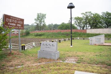
| − | + | This is the western triangulation station of the Ganseong Baseline. It is made of granite and measures 30x30 cm. The station was buried during the Korean War (1950-1953), excavated in 1997, and housed in a protective chamber in 2010. Together with the eastern station, it was designated as a National Registered Cultural Heritage in 2020. | |
| − | |||
| − | |||
| − | |||
| − | |||
| − | |||
===영문 해설 내용=== | ===영문 해설 내용=== | ||
2022년 11월 7일 (월) 13:38 판
| 고성 간성기선 서단 杆城基線 西端 |
|
 간성기선 동단, 서단, 고성군청 미디어홍보관. |
|
해설문
국문
기선(基線)은 토지측량에 있어서 기준 되는 선이다.
간성기선은 일제강점기인 1912년 강원도에 유일하게 설치된 기선이다. 기선이란 삼각법을 이용해 두 지점 사이의 거리를 구하는 삼각측량에서 기준이 되는 한 변을 말한다. 1912년 당시 측량 결과에 따르면 이곳 서단과 동단(간성읍 교동리 976-25번지) 사이의 거리는 3,126m이다.
일제강점기인 1910년대 일제는 우리나라를 식민 통치할 목적으로 대대적인 토지조사사업을 시행하였다. 당시 국토 전역을 23개의 삼각망으로 나누고 전국 13개소(지금의 북한지역 7개소, 남한지역 6개소)에 기선을 설치하여 각 기선 사이의 거리를 정밀하게 실측하였다. 이때 설치된 간성기선은 강원도 지역의 지형과 거리 등을 측정하는 기준이 되었다.
서단 기준점을 표시한 반석은 가로 30cm, 세로 30cm 크기의 화강암으로 만들었다. 한국전쟁 때 매몰되었던 것을 1997년 발굴하였고, 2010년 보호각을 설치하는 등 현재의 모습으로 주변을 정비하였다. 동단과 서단의 반석은 ‘고성 구 간성기선점 반석’이라는 이름으로 2021년 국가등록문화재로 등록되었다.
영문
Western Station of Ganseong Baseline, Goseong
The Ganseong Baseline was established in 1912 during the Japanese colonial period (1910-1945) to precisely measure distances and terrain in the Gangwon-do region as part of a colonial land survey that divided the Korean Peninsula into 23 triangular nets using 13 baselines. Each end of the baseline was marked with a fixed triangulation station that could be used to determine the precise location and distance of a third point. The Ganseong Baseline is the only such baseline in Gangwon-do Province and measured 3,126 m in length at the time of its establishment.
This is the western triangulation station of the Ganseong Baseline. It is made of granite and measures 30x30 cm. The station was buried during the Korean War (1950-1953), excavated in 1997, and housed in a protective chamber in 2010. Together with the eastern station, it was designated as a National Registered Cultural Heritage in 2020.
영문 해설 내용
간성기선은 일제강점기인 1912년 강원도에 유일하게 설치된 기선이다. 기선이란 삼각법을 이용해 두 지점 사이의 거리를 구하는 삼각측량에서 기준이 되는 한 변을 말한다. 1912년 당시 측량 결과에 따르면 이곳 서단과 동단(교동리 976-25) 사이의 거리는 3,126m이다.
일제강점기인 1910년대 일제는 한국을 식민 통치할 목적으로 대대적인 토지조사사업을 시행하였다. 당시 국토 전역을 23개의 삼각망으로 나누고 전국 13개소(지금의 북한지역 7개소, 남한지역 6개소)에 기선을 설치하여 각 기선 사이의 거리를 정밀하게 실측하였다. 이때 설치된 간성기선은 강원도 지방의 지형과 거리 등을 측정하는 기준이 되었다.
서단 기준점을 표시한 반석은 가로 30cm, 세로 30cm 크기의 화강암으로 만들었다. 한국전쟁 때 매몰되었던 것을 1997년 발굴하였고, 2010년 보호각을 설치하였다. 동단과 서단의 반석은 2021년 국가등록문화재로 등록되었다.
참고자료
- “간성기선(杆城基線) 국가등록문화재 등록 검토”, 『2021년 제1차 문화재위원회 근대분과 회의록』, 문화재청. https://www.cha.go.kr/cop/bbs/selectBoardArticle.do?nttId=78722&bbsId=BBSMSTR_1019&mn=NS_03_03_04
- “고성 구 간성기선점 반석 국가등록문화재 등록”, 『2021년 제2차 문화재위원회 근대분과 회의록』, 문화재청. https://www.cha.go.kr/cop/bbs/selectBoardArticle.do?nttId=79052&bbsId=BBSMSTR_1019&mn=NS_03_03_04
- 고성 구 간성기선점 반석, 국가문화유산포털, 문화재청. https://www.heritage.go.kr/heri/cul/culSelectDetail.do?ccbaCpno=4413208060000