"건평돈대"의 두 판 사이의 차이
(→영문) |
|||
| 31번째 줄: | 31번째 줄: | ||
An outpost, called ''dondae'' in Korean, was a small camp set up at a distance from the main military station. It was used to monitor the enemies’ movements and to stand guard against unauthorized intrusions and surprise attacks. | An outpost, called ''dondae'' in Korean, was a small camp set up at a distance from the main military station. It was used to monitor the enemies’ movements and to stand guard against unauthorized intrusions and surprise attacks. | ||
| − | Ganghwado Island has been a | + | Ganghwado Island has been a strategic military defense location for over a millennia. It is located at the mouth of the Imjin and Han Rivers, which pass by the capitals of the Goryeo dynasty (918-1392), Gaeseong, and the Joseon dynasty (1392-1910), Hanyang (present-day Seoul). It was the temporary capital of Goryeo during the Mongol invasions from 1232-1270. The famous Incheon Landing of the Korean War also occurred near here, and today it is near the border with North Korea. |
In 1679, during the Joseon dynasty, Minister of Military Affairs Kim Seok-ju (1634-1684) recommended the construction of outposts in Ganghwado Island to King Sukjong. Yun I-je (1628-1701), a local magistrate, led the '''practical establishment''' of 48 outposts. These outposts were constructed on the coastal upland of Ganghwado Island, with artillery '''emplacement''' surrounded by high stone walls. | In 1679, during the Joseon dynasty, Minister of Military Affairs Kim Seok-ju (1634-1684) recommended the construction of outposts in Ganghwado Island to King Sukjong. Yun I-je (1628-1701), a local magistrate, led the '''practical establishment''' of 48 outposts. These outposts were constructed on the coastal upland of Ganghwado Island, with artillery '''emplacement''' surrounded by high stone walls. | ||
2018년 7월 17일 (화) 14:42 판
| 건평돈대 |
|
| 대표명칭 | 건평돈대 |
|---|---|
| 한자 | 乾坪墩臺 |
| 주소 | 인천광역시 강화군 양도면 건평리 산39 |
| 지정번호 | 인천광역시 기념물 제38호 |
| 지정일 | 1999.03.29 |
| 분류 | 유적건조물/정치국방/성/성곽시설 |
| 소유자 | 산림청 |
| 수량/면적 | 1곽 / 2,600㎡ |
|
|
|
해설문
국문
돈대는 적의 움직임을 살피거나 공격에 대비하기 위해서 감시가 쉬운 곳에 설치하는 초소이다. 밖은 성곽을 높게 하고 안은 낮게 하여 포를 설치해 두는 시설물로, 대개 높은 평지에 쌓는다.
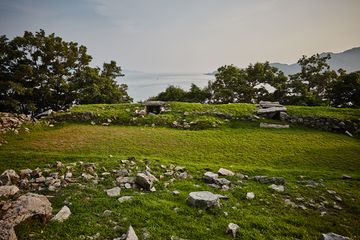
이 돈대는 조선 숙종 5년(1679)에 강화유수 윤이제가 축조한 여러 돈대 중의 하나로 정포보(井浦堡)에 속했다. 석모리 앞바다를 향한 절벽 위에 세워져 있는데, 가로 36m, 세로 26m의 직사각형 돈대이다. 성안에는 대포를 올려놓는 포좌 4문이 갖추어져 있고, 돈대 위에는 몸을 숨기고 적을 공격하기 위해 덧쌓은 낮은 담장을 두른 흔적이 있었으나 현재는 남아 있지 않다.
영문
Geonpyeongdondae Outpost
An outpost, called dondae in Korean, was a small camp set up at a distance from the main military station. It was used to monitor the enemies’ movements and to stand guard against unauthorized intrusions and surprise attacks.
Ganghwado Island has been a strategic military defense location for over a millennia. It is located at the mouth of the Imjin and Han Rivers, which pass by the capitals of the Goryeo dynasty (918-1392), Gaeseong, and the Joseon dynasty (1392-1910), Hanyang (present-day Seoul). It was the temporary capital of Goryeo during the Mongol invasions from 1232-1270. The famous Incheon Landing of the Korean War also occurred near here, and today it is near the border with North Korea.
In 1679, during the Joseon dynasty, Minister of Military Affairs Kim Seok-ju (1634-1684) recommended the construction of outposts in Ganghwado Island to King Sukjong. Yun I-je (1628-1701), a local magistrate, led the practical establishment of 48 outposts. These outposts were constructed on the coastal upland of Ganghwado Island, with artillery emplacement surrounded by high stone walls.
Geonpyeongdondae Outpost, stands on an offshore cliff facing Seongmodo Island and belonged to Jeongpobo Fort. It has four artillery platforms, and its stone walls form a rectangle, measuring 36 m by 26 m in length. There are traces of lower walls which were used by soldiers to shield their bodies during battle.
