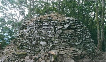
완주 탄현봉수
| 완주 탄현봉수 |
|
 완주 탄현봉수, 국가문화유산포털, 문화재청. |
|
| 대표명칭 | 완주 탄현봉수 |
|---|---|
| 한자 | 完州 炭峴烽燧 |
| 주소 | 전라북도 완주군 운주면 금당리 산 45 |
| 지정(등록) 종목 | 전라북도 기념물 제139호 |
| 지정(등록)일 | 2019년 11월 15일 |
| 분류 | 유적건조물/교통통신/통신/봉수 |
| 시대 | 삼국시대 |
| 수량/면적 | 1기 |
| 웹사이트 | 완주 탄현봉수, 국가문화유산포털, 문화재청. |
|
|
|
해설문
국문
봉수대는 낮에는 연기(燧)로, 밤에는 횃불(烽)을 들어 정해진 신호를 보내는 통신시설이다. 우리나라에서는 삼국시대부터 봉수가 설치되었으며, 1894년 근대통신수단이 도입될 때까지 사용되었다. 신호가 잘 보이도록 산봉우리의 시야가 트인 곳에 봉수를 설치하고, 평화로울 때 1개, 적이 나타나면 2개, 적이 경계에 접근하면 3개, 경계를 침범하면 4개, 경계에서 아군과 전투를 벌이면 5개의 신호를 올렸다.
완주 탄현봉수는 탄현 서쪽 능선의 정상(해발 457.4m)에 자리하고 있다. 탄현은 삼국시대의 전략적 요충지였으며, 주변에 탄현산성, 용계산성, 불명산 봉수대 등의 유적이 분포하고 있다.
자연암반 위에 축조된 원통형의 석축시설은 서벽 전체 및 동벽 일부가 훼손되었으나, 북벽과 남벽은 잔존상태가 양호하다. 남벽 아래쪽에서는 방형 기단의 일부가 발견되었다. 백제의 봉수 형태가 방형이고 가야계 유물이 확인되는 인근의 봉수 형태가 원통형임을 감안할 때, 백제에서 운영하던 탄현봉수는 어느 시기 한시적으로 가야에서 운영하다 폐기된 것으로 추정된다. 석축시설 주변에서는 회청색 경질토기 조각과 백제 기와 조각 등이 출토되었다.
영문
Beacons were a type of a smoke-and-fire-signal communication system to warn of military events such as enemy invasions. The beacons, which are located atop mountains for visibility, were lit in particular patterns to indicate the severity of the situation, namely, one signal: “No hostile activities detected;” two signals: “An enemy army has been detected;” three signals: “An enemy army has approached the state border;” four signals: “An enemy army has crossed the state border;” five signals: “A battle with an enemy army has started.” In the Joseon period (1392-1910), the information was relayed to the central government through a network of beacon stations across the nation. This system was operational until 1894 when the modern communication system was introduced.
Tanhyeon Beacon (Station?) is located at the highest point (457.4 m above sea level) of the mountain ridge to the west of Tanhyeon Pass. This pass was an important military stronghold during the Three Kingdom period (57 BCE-668 CE). A number of other structural remains are located nearby, including Tanhyeonsanseong Fortress, Yonggyesanseong Fortress, and Bulmyeongsan Beacon (Station?).
The remains of this beacon consist of a round stone structure built on a natural rock. While its western side has completely collapsed and the eastern side is partially damaged, the northern and the southern sides remain in a relatively good state. A part of a rectangular platform was also discovered underneath the southern side of the structure. Considering the fact that the beacons built by the Baekje kingdom (18 BCE–660 CE) were rectangular in shape and the those of the Gaya confederacy (42-562) were cylindrical, it is presumed that this beacon was built by Baekje and for some period of time used by Gaya. Artifacts including fragments of blue-gray unglazed earthenware and Baekje’s roof tile shards were unearthed on the site.
영문 해설 내용
봉수는 횃불과 연기로 적의 침입과 같은 군사정보를 알리던 통신 수단이다. 신호가 잘 보이도록 산봉우리에 설치했고, 평화로울 때 1개, 적이 나타나면 2개, 적이 경계에 접근하면 3개, 경계를 침범하면 4개, 경계에서 아군과 전투를 벌이면 5개의 신호를 올렸다. 조선시대에는 전국의 봉수망을 통해 중앙으로 정보를 전달하였으며, 이러한 제도는 1894년 근대통신수단이 도입될 때까지 사용되었다.
완주 탄현봉수는 탄현(고개) 서쪽 능선의 정상(해발 457.4m)에 자리하고 있다. 탄현은 삼국시대의 전략적 요충지였으며, 주변에 탄현산성, 용계산성, 불명산 봉수대 등의 유적이 분포하고 있다.
자연암반 위에 축조된 원통형 석축은 서벽 전체와 동벽 일부가 훼손되었고, 북벽과 남벽은 비교적 양호한 상태로 남아있다. 남벽 아래쪽에서는 방형 기단의 일부가 발견되었다. 보통 백제의 봉수는 방형이고 가야의 봉수는 원통형임을 고려할 때, 이 봉수는 원래 백제가 사용하다가 한시적으로 가야가 사용하였던 것으로 추정된다. 석축 주변에서는 회청색 경질토기 조각과 백제시대의 기와 조각 등이 출토되었다.
- 첫 문단의 '봉수' 정의는 기존 정의와 약간 다르게 썼음. 탄현봉수가 직봉인지 간봉인지 확인되지 않아, 직봉/간봉에 대한 언급은 생략하고, 국문에 언급된 5개 신호에 대해 추가함.
문맥요소
Nodes
| ID | Class | Label | Description |
|---|---|---|---|
| 완주_탄현봉수 | Object | 완주_탄현봉수 | |
| 완주_탄현 | Place | 완주_탄현 | |
| J35-0139-0000 | Heritage | (전라북도_기념물_제139호)_완주_탄현봉수 |
Links
| Source | Target | Relation |
|---|---|---|
| 완주_탄현봉수 | 완주_탄현 | currentLocation |
| 완주_탄현봉수 | J35-0139-0000 | isDesignatedAs |
참고자료
- 전라북도 완주군, 『완주 탄현봉수』 지정신청 자료, 2018.10.
- “완주 탄현봉수”, 국가문화유산포털, 문화재청. http://www.heritage.go.kr/heri/cul/culSelectDetail.do?ccbaCpno=2333501390000
- ‘탄현 봉수대’, 디지털완주문화대전, 한국학중앙연구원. http://wanju.grandculture.net/wanju/toc/GC07000469