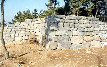
서천 장암진성
| 서천 장암진성 Jangamjinseong Fortress, Seocheon |
|
 서천 장암진성, 국가문화유산포털, 문화재청. |
|
| 대표명칭 | 서천 장암진성 |
|---|---|
| 영문명칭 | Jangamjinseong Fortress, Seocheon |
| 한자 | 舒川 長巖鎭城 |
| 주소 | 충남 서천군 장항읍 장암리 1-11 |
| 지정(등록) 종목 | 충청남도 기념물 제97호 |
| 지정(등록)일 | 1995년 3월 6일 |
| 분류 | 유적건조물/정치국방/성/성곽 |
| 시대 | 고려시대 |
| 수량/면적 | 74,198㎡ |
| 웹사이트 | 서천 장암진성, 국가문화유산포털, 문화재청. |
|
|
|
해설문
국문
장암진성은 해발 90.1m의 후망산 남서쪽 끝에 있는 평지성*이다. 중종 6년(1511)에 성을 쌓기 시작하였으나 바로 중지되었다가 중종 9년(1514)에 완성되었다.
장암진성은 금강 하구에 위치하는데, 이곳은 당나라가 백제를 침략할 때 가장 먼저 상륙한 곳이자 고려 말에는 최무선(崔茂宣, 1325~1395) 장군이 왜적을 격파한 곳으로 역사적으로 의미가 있는 곳이다.
돌로 쌓은 성벽의 둘레는 640m이고 동서 너비 190m, 남북 너비 100m로, 위에서 보았을 때 역사다리꼴에 가깝다. 서쪽 벽은 일제강점기 때 대부분 헐려 형태가 온전히 남아있지 않다. 남쪽과 북쪽에 각각 1개소의 문 터가 있고, 동남쪽과 북동쪽 모서리에는 적을 측면에서 공격할 수 있도록 성벽의 일부를 돌출시켜 쌓은 치(雉)가 있다. 동쪽 성벽 바깥쪽으로 5~7m 떨어진 곳에는 너비 4m, 깊이 1.2m 정도의 방어용 도랑인 해자(垓子)가 확인되었다.
- 평지에 둘러쌓은 성.
영문
Jangamjinseong Fortress, Seocheon
This fortress is built on the flat area in the south-western part of Humangsan Mountain (90.1 m above the sea level). The construction of the fortress started in 1511 but was soon temporarily halted (until when and why?), so the fortress was finished in 1514.
The fortress is located on the western coast of the peninsula close to the estuary of Geumgang River. It is said that this area is where Tang China for the first time landed its troops to attack the Baekje kingdom (18 BCE–660 CE). Also, during the late Goryeo period (918-1392), Admiral Choe Mu-seon (1325-1395) successfully fought the Japanese pirates in these waters.
The fortress wall* measures 640 m in perimeter, and the fortress itself stretches 190 m from east to west and 100 m from south to north. The western wall is a poor condition as most of it collapsed during the first part of the 20th century**. The southern and northern walls each have one gate opening. Also, projecting outward from the south-eastern and north-eastern corners of the wall are bastions, which were designed to attack approaching enemies from the sides. 5-7 m outside of the eastern wall is a trench which was used as a defensive moat. It measures 4 m in width and 1.2 m in depth.
- 돌로 쌓은 성벽: does it mean that “640 m” is the total length of the remaining sections of the wall?
- I guess if we mention the Japanese colonial period here it may cause some confusion, since, as I understand, the collapse of the wall doesn’t have anything to do with the Japanese.
영문 해설 내용
장암진성은 후망산(해발 90.1m)의 남서쪽 평지에 지어진 성이다. 1511년 성을 쌓기 시작한 직후 잠시 공사가 중지되었다가, 1514년에 완성되었다.
장암진성이 위치한 지역은 서해안으로 흐르는 금강 하구 지역으로, 7세기에 당나라가 백제를 침략할 때 가장 먼저 상륙한 곳으로 전해진다. 고려 말에는 최무선(崔茂宣, 1325~1395) 장군이 왜적을 격파하기도 하였다.
돌로 쌓은 성벽의 둘레는 640m이고 동서 너비 190m, 남북 너비 100m이다. 서쪽 벽은 일제강점기 때 대부분 헐려 형태가 온전히 남아있지 않다. 남쪽과 북쪽에 각각 1개소의 문터가 있고, 동남쪽과 북동쪽 모서리에는 접근하는 적을 측면에서 공격할 수 있도록 성벽 일부를 돌출시켜 쌓은 치(雉)가 있다. 동쪽 성벽 바깥쪽으로 5~7m 떨어진 곳에서는 너비 4m, 깊이 1.2m 정도의 방어용 도랑인 해자(海子)가 확인되었다.
참고자료
- 『중종실록』 권14, 중종 6년 9월 4일; 동월 5일.
- 『신증동국여지승람』 권19, 충청도 서천군 관방조. → 실록 기사에는 충청도는 왜적이 침입하는 요해지가 아니기 때문에 축성을 정지하라고 하였다. 그러나 신증동국여지승람에 의하면 1514년 성을 쌓기 시작하여 완공하였음을 알 수 있다. 또한 고려시대에 장암진으로 불리었음을 확인할 수 있다.
- 서천장암진성(舒川長巖鎭城), 문화재청 국가문화유산포털. http://www.heritage.go.kr/heri/cul/culSelectDetail.do?pageNo=1_1_1_1&ccbaCpno=2333400970000#
- 서천장암진성(舒川長巖鎭城), 한국민족문화대백과사전. http://encykorea.aks.ac.kr/Contents/SearchNavi?keyword=%EC%84%9C%EC%B2%9C%20%EC%9E%A5%EC%95%94%EC%A7%84%EC%84%B1&ridx=3&tot=152