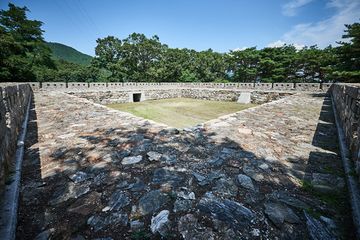
망양돈대
| 망양돈대 Manyangdondae Outpost |
|
 망양돈대, 국가문화유산포털, 문화재청. |
|
| 대표명칭 | 망양돈대 |
|---|---|
| 영문명칭 | Manyangdondae Outpost |
| 한자 | 望洋 墩臺 |
| 주소 | 인천 강화군 내가면 외포리 680번지 |
| 지정(등록) 종목 | 인천광역시 기념물 제37호 |
| 지정(등록)일 | 1999.03.29 |
| 분류 | 유적건조물 / 정치국방 / 성 / 성곽시설 |
| 소유자 | 기획재정부 |
| 관리자 | 인천광역시 강화군청 |
| 수량/면적 | 1곽 / 2,026.0㎡ |
| 웹사이트 | 망양돈대, 국가문화유산포털, 문화재청. |
해설문
국문
돈대는 적의 움직임을 살피거나 공격에 대비하기 위해 영토 내 접경지역, 해안지역 등 감시가 쉬운 곳에 설치하는 방어시설이다. 대개 높은 평지에 쌓으며 밖은 성곽으로 높게 하고 안은 낮게 하여 포를 설치해두는 시설이다.
망양돈대는 조선 숙종 5년1679에 강화유수 윤이제가 황해도·강원도·함경도 승군과 어영청 소속 어영군을 동원하여 쌓았던 여러 돈대 가운데 하나로 정포보井浦堡 관찰하에 있었다. 망양돈대는 대포를 두기 위한 자리와 성에 뚫어 놓은 활 쏘는 구멍인 치첩의 흔적이 남아 있다.
영문
Mangyangdondae Outpost
An outpost, called dondae in Korean, was a small camp set up at a distance from a main military station. It was used to monitor the enemies’ movements and to stand guard against unauthorized intrusions and surprise attacks.
In 1679, during the Joseon dynasty, local magistrate Yun I-je (1628-1701) oversaw the construction of 48 outposts on Ganghwado Island. Six additional outposts were built later. These outposts were constructed on the coastal upland of Ganghwado, with artillery emplacements surrounded by high stone walls.
Mangyangdondae, overlooking Oepori Port to the east and Seokmodo Island to the southwest, was an outpost of Jeongpobo Fort along with Geonpyeongdondae, Samamdondae, and Seokgakdondae Outposts. Its stone walls form a square shape, measuring 130 m in perimeter and 3-3.4 m in height. The southern part of the fort is so steep it is nearly a cliff. Artillery embankments and vertical slits for shooting arrows are located in the outpost's walls.